|
Chapter 6. The Outward View
Oakland is blessed with a beautiful, lively
shoreline that serves as a gathering point for exercise, contemplation,
conversation and celebration. Accessible to all, it provides common
ground for our diverse community and is a singular place of beauty.
This wonderful urban space is the three miles of
shoreline along Lake Merritt. It is the heart of Oakland, central to our
city and community life. It is Oakland's inward view.
Oakland has another nineteen miles of shoreline
- from the wild marshlands of San Leandro Bay; northward along the
Estuary, teeming with water craft of every imaginable type; past the
gigantic cranes of the Outer Harbor to the free-spirited sculptures on
the Emeryville tidelands. This shoreline offers vistas and wildlife, fun
and adventure, and dreams of distant worlds. This is Oakland's outward
view.
Oakland's Historic Retreat from the
Waterfront
Although Oakland has more bay shoreline than any
Bay Area city, it lacks identity as a waterfront city.
Oakland once touched its shore, when ferry
terminals, warehouses and shipyards clustered at the northern Waterfront
and fisheries lined the Estuary. Beginning in the 1930'5, though,
Oakland withdrew from the shore.
The rail tracks along the shoreline always posed
somewhat of a barrier, but until the late 1930's ferry terminals and
industries drew people to the Waterfront nonetheless. Eventually ferry
travel declined, industries closed and new obstructions arose.
World War II brought military bases which
excluded the public from the most of the northern Waterfront for reasons
of national security. Freeways added a formidable obstacle and the
growth of highly mechanized container facilities further restricted
access to the Waterfront.
Today there is little public access to the
shoreline and the Waterfront is detached from Oakland's business and
residential districts. Even Jack London Square is isolated from downtown
and the Oakland Convention Center.
Where Can We Touch the Water?
 This study has divided the Waterfront into three
areas, the Intermodal Gateway, the Estuary Shore and the Airport
Complex. Just as each has a distinct character, defined by topography,
industries and land uses; so too do the recreational and aesthetic
opportunities differ among the areas of the Waterfront. This study has divided the Waterfront into three
areas, the Intermodal Gateway, the Estuary Shore and the Airport
Complex. Just as each has a distinct character, defined by topography,
industries and land uses; so too do the recreational and aesthetic
opportunities differ among the areas of the Waterfront.
Map One shows the public access points on the
Waterfront. The following provides a general description of each area.
The lntermodal Gateway
Major Features: This is one of the
world's great land/sea transportation hubs. The enormous cargo cranes
and container ships convey a sense of power and importance. This is one
of the most exciting parts of the Waterfront. However, the large
military reservations and concerns for public safety in the marine
terminal area have restricted access to this area.
Public Access: Currently there is only
one public access point in the Intermodal Gateway, a one-acre park in
the Middle Harbor. Until recently, access was also available at Port
View Park, a 4.5 acre area containing an observation platform. This park
was closed after the Loma Prieta Earthquake, and will be reopened after
the Port of Oakland completes the relocation of Seventh Street late next
year.
The Estuary Shore
Major Features: The Estuary is a lively
"water boulevard" with an unending parade of water crafts. It also
offers a wide variety of recreation, including boating, fishing and jet
skiing. The shoreline contains restaurants, small boat repair and other
commercial enterprises, many of which are water oriented.
Public Access: There are several
mini-parks and fishing piers in this area. Water-oriented commercial
developments and marinas are concentrated at Jack London Square and
Embarcadero Cove. The new ferry service from Jack London Square revives
passenger travel through the Waterfront, and offers commuters wonderful
contact with life on the Estuary. The Potomac, FDR's Presidential yacht
is docked at Jack London Square and houses a small museum. Bike and
pedestrian pathways have been constructed along several sections of the
Estuary Shore, but the lack of a continuous pathway prevents travel for
any significant distance.
The Airport Complex
Major Features: The undeveloped shoreline
of this area, curving along San Leandro and San Francisco Bays, offers
sparkling vistas. The extensive wetlands, marshes and sloughs contain an
amazing array of wildlife.
Public Access: Martin Luther King, Jr.
Regional Shoreline Park is 565 acres of dedicated open space consisting
of bay and wetland. A trail system provides restricted access to
delicate natural areas and along Tidal Canal and Doolittle Pond. Picnic
areas, boat launch facilities and fishing piers are also available at
the park. Galbraith Golf Course is located southeast of the Oakland
International Airport. The future of this facility is in doubt, since
the Port of Oakland has selected it as a disposal site for dredge
spoils.
A New Approach to the Water: The Bay Trail
Another form of public access is by pedestrian
and bike trail. Only a few miles of trail are presently available, but a
new effort has begun to develop a continuous path along the Waterfront
and between the Waterfront and inland attractions.
In 1987, the State Legislature adopted Senate
Bill 100 to authorize planning of a trail around San Francisco and San
Pablo Bays. The Association of Bay Area Governments (ABAG) was assigned
the task of coordinating the trail's development.
The Bay Trail Plan, adopted in 1989, is a
400-mile network of multi-use pathways through all nine Bay Area
counties. The key component of the system is a "spine trail" which will
create a continuous path around the Bay. "Spur trails" will connect
points of natural, historic and cultural interest along the shoreline
and "connector trails" will link the main trail to recreational sites,
residential areas and employment centers inland from the bay.
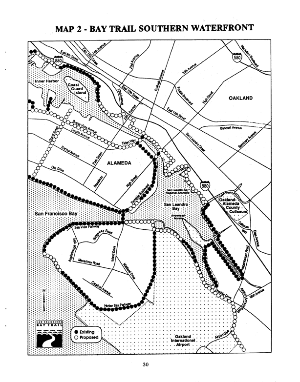
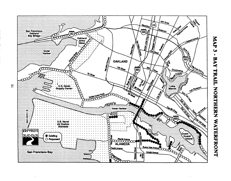
 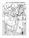 Maps Two and Three show the proposed trail
network within Oakland. Maps Two and Three show the proposed trail
network within Oakland.
The main trail will ultimately provide a
continuous pathway along the entire Waterfront. Spur and connector
trails will link the Waterfront westward to the Alameda City bayfront
and eastward to other trail systems, such as around Lake Merritt.
The problems which must be overcome to complete
the Bay Trail on Oakland's Waterfront illustrate the difficulty of
obtaining public access within an intensely developed area.
-
While some sections of the Bay Trail will be
on exclusive bike/pedestrian paths, most will utilize existing
public streets and sidewalks. This compromises the recreational
experience and results in a conflict between automobile and bike or
pedestrian traffic.
-
Some parts of the Waterfront are so heavily
developed that a continuous pathway cannot be built along the shore.
For example, shoreline industries in the High Street and the
Twenty-ninth Avenue areas cause the Bay Trail to be located several
blocks from the water.
-
Since the Intermodal Gateway is a major
truck and rail hub, heavy traffic and the presence of tracks in
public streets pose hazards to bicyclists and pedestrians. The Port,
City and ABAG are working to solve these problems, such as by
designing protected pathways along existing streets.
A total of 2l miles of Bay Trail is planned for
Oakland's Waterfront. At present, 8.5 miles have been completed,
consisting of 6 miles in the Airport Complex and 2.5 miles in the
Estuary Shore. Another 1.5 miles (of a planned 7 miles) are now under
construction in the Intermodal Gateway.
Vistas and Visions
Two questions are paramount in considering the
future development of public access to the Waterfront:
Response to the first question begins with
recognition of the distinct aesthetic, recreational and educational
potential of each area of the Waterfront and the problems which must be
overcome to tap that potential.
For example, the Intermodal Gateway conveys an
awesome impression of international commerce and seafaring adventure.
However, safety considerations restrict public access within the marine
terminal. The challenge is to provide view opportunities without
endangering the public.
In 1986, the Bay Area Partnership convened a
workshop to explore new visions for Oakland's western gateway. This led
to the realization that, although several hundred thousand people cross
the Bay Bridge each day, harbor operations are obscured from view. The
workshop resulted in drawings which showed how view corridors could be
created from the roadway and a vista point could be developed near the
Toll Plaza. Views from these points would display a powerful image of
Oakland and enable the public to capture the excitement of the harbor,
without interfering with Port operations.
The second question involves recovering
Oakland's heritage as a Waterfront city. Its answer has both a physical
and an educational aspect.
The physical orientation of Oakland is inward. T
o recover the identity of a Waterfront city, we must form links from the
downtown and neighborhoods to the shoreline and create public spaces at
important points along the Waterfront. The Bay Trail, with its
connections to inland parts of Oakland, is an excellent start. A
continuous pathway between Jack London Square and Lake Merritt, for
example, would once again link the Waterfront and the downtown. The
proposal to locate Oakland's Amtrak terminal at Jack London Square would
also help restore the Waterfront as a crossroad of passenger travel.
The educational aspect of public access is often
ignored. As a Waterfront city, Oakland has an especially rich heritage
and great educational opportunities. Port operations are a vivid example
of international business, world history and geography. The
intercontinental railroad, World War II shipyards and early aviation
adventures at North Field are not only an integral part of our local
heritage, but also lead to a broader understanding of the social and
economic changes which shaped our nation. The marshland of San Leandro
Bay is an unexcelled laboratory of marine life.
Not only should our schools use the assets of
our Waterfront, but public access points should also include
interpretive programs to teach and inspire.
Looking Outward at the Possibilities
The central role which Lake Merritt plays in
Oakland's community life illustrates the vitality that a shoreline gives
to a city. However, Oakland's other shoreline - its outward view - is
detached from community life.
The power of a harbor, the challenge of sailing
and fishing, the energy of shoreline commerce and contact with our
natural environment are only available in waterfront cities. These are
assets that we can capture by once again looking outward to Oakland's
Waterfront.
<
Previous Chapter |
Table of Contents
| Next Chapter > |