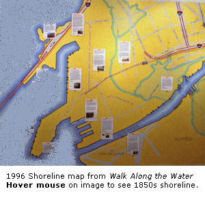
The Shoreline - How it Used to Be

 You
can get a sense of how much the shoreline has changed since we began to
alter the landscape in the early 1850s. It has changed so much that it's
hard to imagine that what was once wetland is now city streets.
You
can get a sense of how much the shoreline has changed since we began to
alter the landscape in the early 1850s. It has changed so much that it's
hard to imagine that what was once wetland is now city streets.
The information on this map about the shoreline was compiled from
several maps made in the 1860s and 1870s. The locations are approximate,
but you get the general idea.
Deborah Cooper
Oakland Museum of California
 "Walk Along the Water"
© Oakland Museum of California, used with permission.
 Explore this
Topic:
Explore this
Topic:
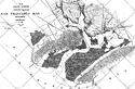 1856 survey map of Oakland-Alameda
waterfront - U.S. Coast Guard
1856 survey map of Oakland-Alameda
waterfront - U.S. Coast Guard
(Note landforms, including extensive marshlands.)
 back to history map