|
Gateway Park - the Judge John Sutter
Regional Shoreline

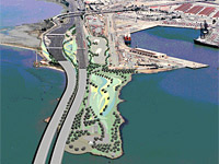 Located
at the foot of the new east span of the Bay Bridge on former Oakland
Army Base land, this shoreline park is being developed as a gateway to the
East Bay. Located
at the foot of the new east span of the Bay Bridge on former Oakland
Army Base land, this shoreline park is being developed as a gateway to the
East Bay.
Featuring
spectacular shoreline views of San Francisco from its 600-foot
observation pier, the park serves as the
jumping-off point for the Bay Trail to join the Bay Bridge bike path to
Treasure Island. The park site is also the location
where the East Bay’s historic Key System trolley line met the San
Francisco ferries to cross the bay. Interpretive park features commemorate this transportation node, including the history of the old
and new Bay Bridges.
The park is named for John Sutter, the retired East Bay
civic and environmental leader who spearheaded its
development. For decades, Judge Sutter has been
instrumental in obtaining and preserving public access to
the bay shoreline.
 back to waterfront access map
More Information
 Visit the
East Bay Regional Parks web page for the Judge John Sutter
Regional Shoreline.
Visit the
East Bay Regional Parks web page for the Judge John Sutter
Regional Shoreline.
 Status Status
The park opened in October of 2020. Park development is expected
to continue.
Planning was organized by the
Gateway Park
Working Group, a consortium of nine agencies, including the Bay Area Toll Authority (BATA),
Caltrans, Bay Conservation and Development Commission (BCDC), California
Transportation Commission (CTC), East Bay Regional Park District (EBRPD),
City of Oakland, Port of Oakland, East Bay Municipal Utility District (EBMUD)
and Association of Bay Area Governments’ (ABAG’s) Bay Trail Project.
Location & Sky View
Internet Explorer users: Do
not click [+] to zoom in due to recent bug in Google
Maps.
Drag, zoom:[+][-], switch from Satellite to
Map or Earth view, explore...
Click the marker
for driving directions. marker
for driving directions.
View Larger Map
back to waterfront access map
|