|
Embarcadero Shoreline Parks and Trails

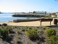  There
are many superb opportunities for public waterfront access hidden along
the Embarcadero in a strip stretching from the 9th Avenue Terminal to
Embarcadero Cove. Here, a series of intermittent shoreline paths links
pocket parks, piers, marinas, restaurants and various businesses. The
paths, which are part of the
Bay Trail, offer views of the estuary,
marinas, and Coast Guard Island. There are occasional interruptions in
the shoreline path, but the route continues along the Embarcadero in
these areas. There
are many superb opportunities for public waterfront access hidden along
the Embarcadero in a strip stretching from the 9th Avenue Terminal to
Embarcadero Cove. Here, a series of intermittent shoreline paths links
pocket parks, piers, marinas, restaurants and various businesses. The
paths, which are part of the
Bay Trail, offer views of the estuary,
marinas, and Coast Guard Island. There are occasional interruptions in
the shoreline path, but the route continues along the Embarcadero in
these areas.
 back to waterfront access map
More Information
 Visit our
detailed page on
the Embarcadero Shoreline, which describes shoreline
access opportunities
and presents many pictures.
Visit our
detailed page on
the Embarcadero Shoreline, which describes shoreline
access opportunities
and presents many pictures.
Status
 Open and evolving. Measure DD will provide for
additional Bay Trail linkages in this area. Open and evolving. Measure DD will provide for
additional Bay Trail linkages in this area.
Funding
Development. The parks and trails
were funded in part by private waterfront developers as they
met obligations imposed by the
Bay Conservation and
Development Commission. Trail improvements will be
funded by Measure DD using part of $19.3 million allocated
for Bay Trail connections.
Maintenance. The mini-parks along this shoreline are maintained by the City of
Oakland with funds provided by the
Landscaping
and Lighting Assessment District.
Location & Sky View
Drag, zoom:[+][-], switch from Satellite to
Map or Earth view, explore...
Click the marker
for driving directions. marker
for driving directions.
View Larger Map
back to waterfront access map
|